cartagen.smooth_topographic#
- smooth_topographic(geometry, iterations=2, angle=10.0, weights=[1.0, 2.0, 1.0])#
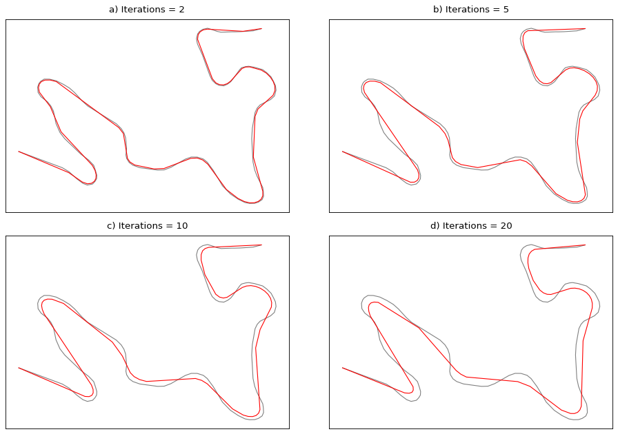
Smooth a line or polygon and mimic hand-made cartographic generalization.
This algorithm described in Müller and Wang [1] combines both a low-pass filter using weighted moving average (WMA), and a high-pass filter using an angular threshold. It is suitable to smooth topographic features such as rivers, coastlines, lakes, etc. and simplify it to mimic hand-made generalization.
Accept Multi geometries. If a polygon is provided, it also applies the smoothing to its holes using the same parameters.
- Parameters:
geometry (
LineString,MultiLineString,Polygon,MultiPolygon,LinearRing) – The geometry to smooth. If an open line is provided, the endpoints are preserved. If a closed ring or polygon is provided, the smoothing wraps around.iterations (
int, optional) – Number of low-pass filter passes before thinning. Default is 2.angle (
float, optional) – Turning-angle threshold in degrees for the high-pass step. Default is 10.0.weights (
sequenceofodd length, optional) – Weights for the moving average window. Default is [1, 2, 1].
- Returns:
LineString,MultiLineString,Polygon,MultiPolygon,LinearRing– Simplified geometry of the same type as input.
See also
smooth_gaussianSmooth a line or a polygon and attenuate its inflexion points.
smooth_platreSmooth a line and preserve the integrity of sharp turns.
smooth_snakeSmooth a line or polygon using the snake method.
smooth_taubinSmooth a line or polygon and prevent shrinkage.
smooth_wmaSmooth a line or polygon using a low-pass filter.
Examples
>>> line = LineString([(0, 0), (1, 0.9), (2, 0.1), (3, 1), (4, 0)])
>>> simplify_topographic(line, 1, 15.0)
<LINESTRING (0 0, 2 0.5, 4 0)>